About four years ago, I pulled my novel Red Soil Through Our Fingers from distribution on Amazon. My reasons at the time are outlined in a blog post wrote at the time. While I believe the reasons I had for my boycott are still valid, I’ve had to weigh continuing it — at least in my author life — against the cost of maintaining it to my growth as a writing life . The result is that, after long deliberation, I have resumed distribution of my published writing on the Kindle Bookstore.
The two things anyone will tell you are absolutely essential for an indie author in the present are 1) social media, and 2) Amazon. Having also given up basically all social media around the same time (it was essentially a boycott of Google, Facebook, Twitter, Amazon, and all of their subsidiary services), I eliminated nearly all of the avenues available to an indie author to build and maintain a community of followers and fans.
For the last few years, this didn’t actually matter that much — for a variety of reasons (see upcoming IWSG post on January 5!), I had largely stopped writing. But as I’ve started to reengage with writing and set new goals, I’ve had to consider the implications of cutting off the two main supply lines of oxygen to an indie writer’s prospects. Like it or not, Amazon and mainstream social media have grown to have a complete chokehold on anyone chances of getting their work out to a community that would.
Despite protests to the contrary, Amazon has near-total global monopoly on ebook content. About 75% of ereaders in the United States are Kindles. In the UK it is closer to 90%. And while it was possible for Kindle users to access my books by purchasing a copy on Smashwords and manually downloading and transferring the mobi file to their Kindle device… I’m sure no one ever does that. Especially without any other way to find me on social media.
I decided that I had to relax at least one constraint.
And if it was between turning Kindle distribution back on versus returning to social media, the choice to me is easy. Creating new accounts and grinding in the cesspools of what Facebook and Twitter have become in order to establish a following again seems both time consuming and detrimental to a contentedness I regained only after giving them up. Not to mention how fake I would feel posting things just to try and keep an author following! And besides — I have a newsletter for reaching out to my community, and I’m just fine with that.
I can’t say I’m happy about it per se, and I still continue to boycott Amazon where possible in my personal life; however, I do hope that this change allows more people to access my work going forward.
I was happy to work with my friend Trish Revolinksy for the release of my first directly published short story, Anpo (The Dawn). You can learn more about the story in the blog post for its release.
Below is an interview with Trish about the cover. Thanks for answering all these questions and for this wonderful collaboration!
How would you describe the cover?
The cover is of the modern science fiction variety. It emulates Kim Stanley Robinson’s first edition covers of the Mars trilogy and Andy Weir’s The Martian. Both covers give the subject and setting of their stories to the reader using only the cover and I was inspired by that approach. In this cover, there is a planet covered by storms that is ambiguous when examined alone, but is confirmed as Earth when you spot Earth’s moon tucked behind the planet. The cover shows my interpretation of the moment the Swirl takes place. The space vehicle is prominently placed and interacting with the Swirl.
This is the first time you’ve done a book cover, correct? What new things did you have to consider and what changes did you have to make to your usual artistic process?
Yes, this is my first book cover! The most prominent and new things I had to consider were pixels and quality of the images I used. At one point in the process, I had a grainy moon and a crisp planet that distracted from my intended focus of the cover, which is the Swirl. Most of my past projects made in graphics editing software were for personal use and I was not concerned about image quality or content source since the result would live in my computer and never be used elsewhere. For this project, I was very careful of image source and permissions and ensuring the cover image quality translated for a thumbnail up to a zoomed in image on a large monitor. It forced me to be very deliberate with my image choices and to revisit design choices when I encountered difficulties with image copyright or quality. It changed my process to a more structured method that required more planning. The structure was different, but a nice learning experience.
Cover art could be described as an act of translation (from words to images) and visual summary (conveying quickly what this story is about). Why did you choose the elements you did as being the most important to convey to a potential reader?
I wanted to convey the urgency of the story with each cover element. The massive storm covering the visible planet indicates that all is not well on the planet and in the story. There is a sense of danger and mystery that the hurricane represents. Saveen is at the center of his story and humanity’s story. While he is not experiencing the immediate danger of the story moving around him, he is trapped in the middle of it all. He carries the responsibility of a task placed on him that requires so much sacrifice. I echoed the eye of the storm in the center point of the Swirl to draw that parallel between the events on Earth and events in the Swirl. The vehicle where Saveen enters the Swirl is near the planet, but held at a distance to demonstrate in a physical sense how Saveen is valued but forced outside humanity. The moon is visually close to the planet to further isolate the Swirl from every other human. I also did not include stars on this design because they represent hope and offer an escape. I wanted to reinforce that the Swirl is the only route Saveen can take.
Would you change your approach to creating future book covers based on your experience with this one?
I would change my approach for future book covers by being more deliberate with the plan going into each cover design. This cover and alternate covers started with a general idea of the style I wanted to use. I then added elements and removed them as the design shifted. It took a number of iterations to reach a design I was comfortable sharing for review. I would definitely plan out the designs more before even starting to build a cover next time.
Are you open to new commissions for cover art or art in general? If so, what are you interested in doing and how can people contact you?
Absolutely! I enjoy exploring different art forms and learning about other creative processes. Working with others helps me to learn more and I am all about it! People are welcome to reach out on instagram @trickaject or by email to [trickajet at gmail dot com].
I’m excited to announce the release of my first directly self-published short story, Anpo (The Dawn)! The story is available as a free ebook directly from Smashwords. (Barnes and Noble, Kobo, Apple Books, and others also available).
Back Cover: Saveen has been selected out of many candidates to become the Storyteller, a person who will represent humanity to an unnamed entity via the Swirl, an orbital interface in spacetime. The task is mentally taxing and estranging, and he must also undergo various biotech enhancements that come with ethical and emotional costs. Meanwhile, humanity has some hard questions to answer about its past, and the future it is creating for itself. When the Swirl is activated, all does not go according to plan… and Saveen learns that the role we play in history may not be the one we intended.
The cover art is an original creation by my friend and colleague, Trish Revolinksy. Stay tuned for an interview with Trish in a future blog post!
Also for a future blog post: the interesting journey of this story. It’s been both highly praised and scathingly critiqued by various editors, undergoing seventeen rejections, an enthusiastic acceptance, years of pre-publication purgatory, and a withdrawal over four years of revisions under five different titles. I think its a great case study in looking at the vagaries of short story publication… more on that later!
On the first Wednesday of every month, members of the Insecure Writer’s Support Group (open to anyone and full of great resources and information for writers) post their answers to a monthly prompt on their blogs.
Authors benefit from getting an insightful prompt for generating more blog content, and ISWG links all respondents, which is a way for writers to discover each other. Pretty neat!
September 1 question – How do you define success as a writer? Is it holding your book in your hand? Having a short story published? Making a certain amount of income from your writing?
I think the most succinct way of defining writing success to me is: Successfully sustaining the craft of using imaginative worlds to explore aspects of the human condition that I find interesting, with people who want to engage with these ideas. That’s pretty abstract, so I’ll try and break down in more concrete terms what that statement does and does not mean to me.
Success includes:
The independence to write what I want, when I want — without the pressure of arbitrary deadlines or obligations
The independence to not have to promote myself all the time (via social media, publicity events, etc)
Publishing quality work in a form that makes it easily accessible and distributable to those interested in it
Income on published work that offsets the up front costs of creating it (such as paying for freelance editing, commissioning a book cover, etc)
Having a “small but mighty” cadre of dedicated readers of my work, who regularly find it valuable, entertaining, and thought-provoking
Feedback and engagement from family, friends, and fans that help me explore the issues I write about
Success does not include:
Being famous
Making a lot of money from writing
Book tours
NY Times Bestseller lists
Movie deals
Interviews
Having a lot of followers
Anything else related to the “celebrity side” of being an author
An interesting personal discovery that occurred to me while writing the above: I think my definition of success helps explain why I don’t really consider traditional publishing an attractive option vs self-publishing. Traditional publishing offers the potential for a lot of the definitions of success I don’t really care for, while trading away two of the most important aspects of success that I do care about: the independence aspects. Not to mention, the increased uncertainty (endless querying, waiting, random rejections, etc) and long wait times (as the publisher moves through the machine of steps in their production process) that come with traditional publishing don’t seem remotely worth it.
This exercise has also made me grateful that I can afford to say I don’t need to pay my bills with writing. I have a day job that I really enjoy. It would be great to break even so that the craft is sustainable, and hey, maybe I’ll be a writer when I retire — but it’s nice to be able to say I can choose not to do something!
This entry is part 2 of 6 in the series How I Write
Many years ago, I was living in Boston during the time I first began intentionally trying to move from “hobby writer” (which I think I’ve been rather continuously since childhood) to something more like “semi-pro” (that is, try and get a few things published somewhere, and maybe get paid something for it once in awhile).
As part of this process, I attended writing classes at a local writing center (in Boston that would be GrubStreet, and I don’t mean the New York food magazine), and I also went to a lot of science fiction and fantasy literary conventions. (I highly recommend these two general approach of getting more involved in the literary world.)
I can’t remember if it was at Boskone or Arisia, but at one of these Boston cons I attended a writing panel that featured Jeanne Cavelos, founder of the Odyssey Writing Workshop for writers of science fiction, fantasy, and horror. Ms. Cavelos did not have any idea who I was (nameless young writer in the crowd), and I’m pretty sure she still does not — nor will she probably ever — have any idea who I am.
But she changed my writing life.
The Three-Egg Structure
Jeanne Cavelos massively upgraded my approach to writing by introducing me to one of the most common and useful templates for framing the big-picture structure of a story: The Three-Egg Structure.
Wait what, you might be saying. Three… did you say… eggs? You mean the Three-Act Structure, correct?
No, no, no — I assure you I mean eggs. You see, Ms. Cavelos has a very strong northern midwestern accent (one might even say, an eggcent). Every time she said the word “act,” I — admittedly sitting near the back and having never heard of this system before for context — definitely heard the word “egg” instead, and all of my furiously scribbled notes from that panel reflect this word swap. (In retrospect, perhaps it was also a good accidental lesson in dialect.) To this day, I think of my novel structures in units of eggs!
Now, I won’t bother to explain the Three-Egg Structure or how to use it here, as there are plenty of resources on the Interwebs already (if you search for “Three-Act Structure” mind you). In particular, there’s a good template for story planning based on this structure on Matt Gemmell’s site. I took the Excel sheet he has posted for download and modified it to my own preferences, and you can do the same! For reference, my version (as both Libre Office and Microsoft Word) is below.
The structure does have its critics, and, you know, fine. But I’ve found it to be an incredibly useful tool for helping me draft and revise. I also find the Three-Egg Structure incredibly useful for merging the two camps of a separate writer concept: Plotting vs Pantsing.
Plotting vs Pantsing, and the Third Way
Possibly the most annoying question (in my mind) that writers ask each other is “Are you a Plotter or a Pantser?” What they mean is, do you plan or plot things out in advance before you start writing, or do you start with a concept and just write “by the seat of your pants” until you get somewhere? The reason I find this question perfectly useless is that I don’t think anyone actually purely does one or the other, even if they say they do. Further, I don’t think it can even be thought of as a continuum, or sliding scale.
I think the more useful question is: What aspects of writing do you generally like to plan in advance, and which aspects do you prefer to discover on-the-fly?
John DeDakis, in a course I’ve blogged about before, introduced me to the term “plantsing,” or mixing and matching techniques from both camps to develop an overall method that works for you, something I’ve long believed in but never had a word for. Thanks John.
So here’s how I plants, and how I finally tie the two seemingly separate segments of this blog post together:
Start with a concept, vague idea, situation, or inner conflict/twist that I think is interesting. Determine what kind of person has the most to lose in this situation, and sketch out a protagonist that would fit this tension.
Determine an initial twist that would be jarring, alarming, or terrible for the protagonist — something significant enough that it is irreversible, and forces a reaction (e.g. no reasonable person in the protagonist’s position could ignore it or choose to look the other way). This goes in “Plot Point 1” on the Three-Egg template. All very Plotting so far!
Start from an interesting situation that occurs prior to Plot Point 1 and helps establish the world and the protagonist’s relationship to it. Free-write (or pants) my way from that situation forward towards Plot Point 1, taking things as they come and allowing the character to react as I think they “naturally” would to the exposition and set up of the world. Since I know where they need to get to in vague terms (the kind of “break” that needs to happen for Plot Point 1), I can nudge things in that direction, even though I don’t know the exact form it’s going to take or how long it will take to get there. This is more of a Pantsing approach… I like to see where the character and the idea lead me, and I generally don’t know what’s going to happen next.
When I reach Plot Point 1, I retroactively fill in the rest of the template for the First Egg. Usually this makes clear which threads that have emerged in the exploratory drafting are actually essential and important. I’ve come back up for air and am doing a bit of Plotting to sort through what I have and set the course for the next bout of Pantsing.
Repeat the above for each major plot point, recognizing that the Turning Point is a change from reaction to action for the protagonist (where they actually stop believing this is going to fix itself somehow and realize they have to Do Something or its just going to keep getting worse).
When nearing the Climax, reconnect the personal to the global… how does what’s going on for the protagonist tie in some meaningful way to the overarching / background events that are happening around her? The Climax should be a breaking point for both simultaneously.
Finish the draft and revise later! Use the Three-Egg template as a coarse tool for organizing general structure in broad strokes on the revision.
Again, you can always move things around, change the overall order of things, change the stakes, or even rewrite whole segments later — and in fact you might need to and this seems to be a normal part of the writing process! That said, I’ve found the Three-Egg Structure, combined with a very ¿porque no los dos? attitude towards Plantsing results in a hybrid model that helps me stay focused and gain many of the benefits of both drafting philosophies.
Happy plantsing! And I hope your story eggs hatch into a beautiful bird novel that both lives up to your initial idea and takes flight in ways you don’t expect.
I recently took my first writing seminar in several years, called “Becoming a Master Writer.” Novelist and editor John DeDakis taught the course (virtually) for The Muse Writing Center in Norfolk. The course covered a variety of topics about craft and the writing life, but one of my major personal takeaways was a new appreciation for the value of journaling and memoir.
I’ve never managed to do much of either — journaling often seems like a waste of time when I could be “actually writing” with that precious discretionary time, and the thought of myself writing a memoir seems more than a little self-indulgent. I would love, for example, to read the memoirs of my great uncle, who began a medical career decades ago in Sri Lanka and for a time was the only doctor for 50,000 people. Or people who lived through trying circumstances (such as wars or periods of great change), or perhaps those who have attained a high level of spiritual insight and want to share the journey. What do I have to say about my life next to any of that?
Mr. DeDakis gave me a new perspective on memoir. He said, “The better you know yourself, the stronger your writing will be.”
He framed the whole act of writing anything, not just the memoir genre as an end-goal, as the translation of our experiences, subconscious, and active imagination onto the page. If our lived experience is the emotional wellspring from which we draw our inspiration (and the lens through which we process the inner life of others), then exploring those depths of the soul might actually be quite useful even if memoir is not our end goal. This all might seem obvious to anyone who journals regularly, but for whatever reason, it had not clicked in this way for me until this course.
I’m working on one of his many suggested exercises: Make a timeline of your life, year by year. Record anything you remember about that year (or know about it secondhand), whatever comes to mind. Include how you felt, who was involved and how you felt about them, and what was going on in the world for context. Then, start drawing connections — are there repeated motifs, trends, themes that emerge? Perhaps these threads of experience are really What You Should Be Writing About, in either fiction or nonfiction.
I have no doubt that journaling and memoir also have intrinsic value as self-reflection, as a goal in and of itself. I look forward to those side benefits as well! However, DeDakis’s framing these activities in the context of how they could actually help my prose fiction serves as a nice motivator.
“Hmmm,” says Homer to Bart in a classic episode of The Simpsons. “Your ideas are intriguing to me, and I wish to subscribe to your newsletter.”
I think that episode aired when I was in middle school. We would quote it all the time, because middle schoolers. (Then this one time in high school, I quoted it to my friend Mike Owen, and then he actually made a newsletter in response as a joke, but then it wasn’t a joke, because it caught on because it was full of jokes, and grew into a decent email circulation for awhile. It was called Floom! and even our teachers thought it was great, which is how you know we were the cool kids.)
Anyway, I made a newsletter. Why? Well for one thing, it’s more targeted and personal than a blog post. While I’ll still use the blog for general announcements and updates with no particular audience, a newsletter targeted at those who want to follow my writerly adventures, with regular cadence issues that appear in your inbox instead of having to remember to check a website somewhere, seems nice and useful for everyone involved.
Further, as I begin work on active writing projects again I realize I probably should try to, you know, communicate with the internet again. Since giving up (to the greatest extent possible) Google, Facebook, Twitter, Amazon, and most of the subsidiary services they own a few years ago, I think I’m definitely much happier. However, I’m inarguably far worse off in terms of positioning as an indie author.
While I have very little desire to enter the world of social media again (nor do I feel like I have to… I have the privilege of saying it’s not as though I need to make my living from selling my writing), I feel as though at the very least I should make it easier for those who *would* genuinely care to engage with my writing and creative process to follow along, and easier for me to connect and engage with you. Hence, newsletter! You get an email delivered and some handy buttons so you as a reader can feel free to share something on Facebook and Twitter if you want to, and I get to stay a social media hermit. It’s win-win, really.
When? Starting… soon. How often? Once a month (probably). What will be in it? I’ve tentatively decided on a general breakdown of:
personal note / update on life
update on writing work in progress
link to and brief commentary on something interesting from the interwebs (a new book/movie/art, an interview/essay related to SFF, etc)
something behind the scenes related to my writing: outtakes, bonus content, the-making-of, sneak preview, etc
We’ll see how it turns out! Feedback and recommendations always welcome. In the meanwhile, if my ideas intrigue you, then you can subscribe to my newsletter at the ground level in time for the very first issue somewhere to the right of this post on the sidebar (or below this post if you’re on a mobile device), where I have surely added a subscription widget before clicking Publish on this post. Surely.
This week I’m celebrating a return to writing. I’ve been thinking about various ideas for quite some time now. But the truth is I haven’t really tried to (and made progress on) any fiction in almost two years.
I’ve been stuck. The reasons are varied — busy with other things and not making the time, not being in the right mental/emotional headspace following many life changes (including a divorce, two position changes at work, moving, something something a global pandemic, etc, etc), and probably a lot of self-criticism that was unhelpful. I think for a long time I’ve prevented myself from writing what I feel like writing because some part of my brain felt I should be writing something else. And, as I’m sure anyone who has attempted a creative pursuit will affirm, creative brain will put up with executive brain bossing it around for only a short while.
So I’m putting aside the sequel to Red Soil Through Our Fingers, which I’ve tried to write three separate times in the past four years only to inevitably start spinning my wheels. I’m also putting aside grander visions of an epic space opera and a fantasy world based on South Asian traditional cosmologies, as well as a few near-future-impact-of-technology short pieces. These are interesting projects, and certainly I hope to complete them at some point — but they really do fall in the should be writing category. Sorry projects!
Instead, at least in the near-term, I’ll be writing straight up fantasy in a homebrew world that I like for no other reason than I think it’s cool. There’s no deep message I’m trying to convey, nor — at least so far — does it have anything to do with anything important. It’s just fun. More on that project later.
Meanwhile, for the consistency problem, I’ve set aside a couple mornings a week for writing and hope to be able to beyond this minimum. I’ve also reconnected with The Muse down in Norfolk, and will be taking a couple of short workshops in June to resharpen the ol’ toolbox and try to get back in the right mindset about the craft of it.
In response to my recent calculation of my annual carbon footprint, I’ve been hunting for ways to offset my carbon emissions resulting from travel. The journey was initially confuddling and full of circles and dead ends, primarily because – unfortunately but completely to be expected – it’s hard to know whom to trust.
An article entitled “The complete guide to carbon offsetting” in The Guardian was my first grounding in some context for how all the different “schemes” fit into a broader context. I also gained some traction when I found many articles, including from the New York Times, that all mention certifying programs that will accredit offset programs as trustworthy and transparent.
I finally converged on the Quality Assurance Standard, developed by the UK Government in 2009 in order to solve the exact problem of figuring out whom to trust on offsets. The QAS certifies that companies and operations meet a 40-point standard, including being compliant with the Kyoto Protocol’s definition of what is a good offset.
Based on the QAS standard, I arrived at two possible avenues of responsible carbon offset: Clear, and Carbon Footprint. While it seems that cheaper offsets per ton of CO2 are available (outside the QAS certification), they may be questionable in their veracity and impact. Clear facilitates a more modular approach, allowing you to pick and choose different activities, such as a particular flight between cities or a commute, and offset its equivalent. Carbon Footprint seems easier to use if you already know the amount of carbon emissions in tons you want to offset, or want to use their tool to calculate it. Both seem mostly geared towards businesses, but allow individuals to offset their own emissions independently.
Since I already knew my total carbon footprint for the year and did not feel like manually reentering all the various inputs on Clear’s site, I went with Carbon Footprint, inputting the total amount for my 2019 air travel: 15 tons of CO2. I was offered various geographical project portfolios to offset the amount, ranging in cost from $122.55 for a “Global Portfolio” to $263.48 for a project based entirely in the UK (which would be domestic/local for this company, so that’s probably why it’s offered).
I chose the one called “Community Projects” for $163.40, based mostly on its additional humanitarian benefits: “Your funding supports a carefully selected range of projects from within developing countries that have strong additional benefits beyond reducing carbon emissions. These include health benefits, saving low-income families money and reducing deforestation. All projects in this portfolio are certified to the Gold Standard and include efficient household cook stoves and clean drinking water projects.” I then added $19.22 to the Global Portfolio for my two round trips to Sacramento in 2020 so far to visit family.
So… based on my estimated annual footprint, neutralizing my air travel brings me down to 37.5% below the US individual average carbon footprint, but alas still hanging out at 2.5x the global individual average. But that’s progress! Onward…
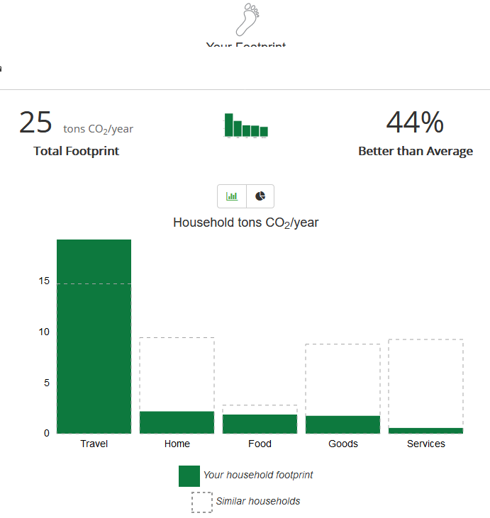
Despite how much I care about and base daily living decisions on thoughts about my climate impact, I realized that I have never once actually sat down and tabulated a detailed estimate of my carbon footprint. So I did.
The general results of the calculation was not surprising, but the sheer size of the contribution from travel shocked me. On the plus side though, it was also personally validating to see how some decisions I have made and stuck to are actually making a difference!
So I mean, you know, if I’m looking for a category in which I could make some improvement… just gotta somehow find one of these that stands out in some way I guess…
The details of my tabulation are below.
Step 1: Establish a Reference. The calculator asks for basic demographic information, including my zipcode (Hampton Roads area, Virginia), the number of people in my household (1), and my gross annual income (I’m a public employee… find me if you can!). These factors provide the statistical baseline for “normal” when comparing to “similar households”.
Step 2a: Transportation – Car. Since I don’t keep track year by year, I estimated my yearly car mileage by taking the total miles on my car (38,000) and dividing by the 3.5 years I’ve owned it to get about 10,850 miles per year. I drive a 2017 Toyota Camry Hybrid, which averages about 40 mpg overall. Note: I did not account for car travel due to work (say to DC or Wallops Island), since in most of these cases I’m given a rental car and I don’t keep track of that mileage, plus some of it is carpooled. I suppose I could ballpark that given known trips I took, but it’s honestly probably in the wash given my air travel…. speaking of which…
Step 2b: Transportation – Air Travel. Ouch. Here’s the category that really hit me! I used 2019 as the year for estimating, since I think it is more “typical” than 2020 for my air travel due to Covid. Since I didn’t have exact mileage, I estimated round-trip flight distances between origin/destination city pairs using an online tool, and then doubled it to account for the return leg. Note that this likely underestimates the total value by a decent amounbt… it doesn’t account for layovers/stops, rerouted flights, or cases where a flight loiters in a holding pattern at a busy airport or flies around weather, etc.
The above chart accounts for both personal and work air travel – a whopping 34,534 annual miles, generating 15 tons of CO2 emissions per year (about 60% of my total footprint). If I were to subtract out work travel (4 domestic trips), my personal air travel by itself (5 domestic trips and 1 international trip) was 21,368 miles, or roughly 6 tons/yr less than my total work + personal. (That alone would improve my relative score to 58% better than average for my income bracket + zip code.)
Step 3: Home Energy Use. I live in a 960 sqft apartment by myself. For the past 12 months (11/4/2019 – 11/2/2020) my energy bills show a total of 5665 kWh used. The calculator includes a slider for how much of your home energy use you offset, which helps me get that nice low result in this category: I offset 100% of my electricity usage through Dominion Energy’s voluntary Green Power program. (Note that customers can select a block option, so it doesn’t have to be all or nothing.) I should note that I don’t think that applying this offset to carbon-footprint directly is totally accurate, as Dominion’s website claims it sources the equivalent of my energy usage from “renewable sources” — which does not necessarily mean carbon-neutral sources. However, I think it’s safe to assume that this certainly a lot better than no offset at all.
Step 4: Nutrition. The “advanced” mode of the calculator allows you to dial in the average number of calories per day you consume from various sources. Thanks to my penchant for tracking my nutrition data on MyPlate over the last year as I simultaneously ramped up running training plans and shifted to a more plant-based diet, I have four separate week-long snapshots of everything I ate during those weeks, at different times of the year. Averaging those shows that the overall effect of a mostly-plant-based diet (I still eat fish and dairy) puts me at about a third below the average carbon footprint for Food.
Step 5: Shopping. This one seemed the most vague of the categories for me, since it basically consists just of two sliders, one each for “Goods” and “Services”, that represent the average dollar amount you spend on each category per month. I wish there were a way to differentiate between locally-sourced or used/up-cycled goods versus new goods shipped from afar; further, the estimate doesn’t differentiate between actually recyclable goods and Horrible Planet Death Plastic of Deception. But, that’s okay, it’s just a model I suppose! It does feel good to see how much below average my general consumption is.
I ran a report on the previous 12 months of my spending from my Quicken accounting software. In the “Goods” category I included everything in my Quicken category “Shopping”, which accounts for clothing, household purchases, etc (think Target, Home Depot, Costco, etc). It does not include Groceries, Auto/Gas, Rent, Insurance, etc. For “Services” I included my Quicken categories for Personal care + Health and Fitness + Education + Entertainment. Once I had the total for each over the last year, I divided by 12 to get an estimate of my average monthly expenditure.
The Covid effect… While 2020 may not be an entirely normal year in this respect, I don’t really buy much in terms of consumer goods and services (almost all of my consumer spending even in a normal year is on travel and dining, the effects of which are accounted for elsewhere), so I feel as though this is probably reasonably accurate.
Conclusions. While I’m pretty pleased about my performance on food, consumption, and home energy use, obviously there is a lot more I could be doing to either curb or offset my transportation emissions.
It would be easy to look at the overall number of “44% better than average” and forget that “average” means the average US consumer in my income bracket and zip code… who apparently generates a completely unsustainable 6.25x the global average individual carbon footprint. In other words, despite being a mostly vegetarian grumpy pseudo-hippie who doesn’t consume much, I’d need to reduce my footprint an additional 36% just to break even with the average American, or an additional 84% to break even with the the average human on Earth… and we need to go much lower together as a planet to have a chance at combating climate change.
This is a case where it is so useful to actually look at data… I have literally thought to myself that surely my green lifestyle more than makes up for my love of travel, perhaps at worst breaking even. Not so — counter to my intuition (wishful thinking?), despite a very eco-conscious lifestyle in every other respect, my travel footprint by itself completely overwhelms my green living.
Looking Ahead. It seems like an impossible target… but I’ve got some ideas. Created a new Category for Sustainability to blog my adventures in this domain. Stay tuned. In the meanwhile, I think I know what my New Year’s Resolution will be… anyone have any tips on where to look for verifiable, effective carbon offset programs for travel? Will report here on what I find…
Edit: Updated my conclusions to reflect more accurate (worse) comparison to US and Global average footprint. Eek.